SimpleFillSymbol
require(["esri/symbols/SimpleFillSymbol"], function(SimpleFillSymbol) { /* code goes here */ });esri/symbols/SimpleFillSymbolSimpleFillSymbol is used for rendering 2D polygons in either a MapView or a SceneView. It can be filled with a solid color, or a pattern. In addition, the symbol can have an optional outline, which is defined by a SimpleLineSymbol.
SimpleFillSymbols may be applied to polygon features in a FeatureLayer or an individual Graphic.
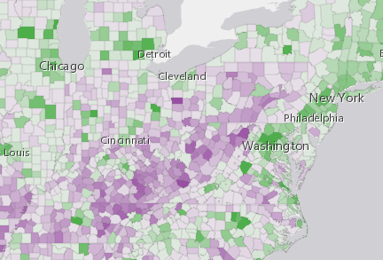
Fill symbols may also be used to symbolize 2D polygon features in a 3D SceneView. However, it is recommended you use PolygonSymbol3D instead. The image below depicts a FeatureLayer whose graphics are styled with a SimpleFillSymbol.
var symbol = {
  type: "simple-fill",  // autocasts as new SimpleFillSymbol()
  color: [ 51,51, 204, 0.9 ],
  style: "solid",
  outline: {  // autocasts as new SimpleLineSymbol()
    color: "white",
    width: 1
  }
};
Constructors
- new SimpleFillSymbol(properties)
- Parameter:properties Objectoptional
See the properties for a list of all the properties that may be passed into the constructor.
Property Overview
| Name | Type | Summary | Class | |
|---|---|---|---|---|
| Color | The color of the symbol. more details | more details | SimpleFillSymbol | |
| String | The name of the class. more details | more details | Accessor | |
| SimpleLineSymbol | The outline of the polygon. more details | more details | FillSymbol | |
| String | The fill style. more details | more details | SimpleFillSymbol | |
| String | The symbol type. more details | more details | SimpleFillSymbol |
Property Details
The color of the symbol. This can be autocast with an array of rgb(a) values, named string, hex string or an hsl(a) string, an object with
r,g,b, andaproperties, or a Color object.- Default Value:[0, 0, 0, 0.25] - black, semitransparent
Examples:// CSS color string symbol.color = "dodgerblue";// HEX string symbol.color = "#33cc33";// array of RGBA values symbol.color = [51, 204, 51, 0.3];// object with rgba properties symbol.color = { r: 51, g: 51, b: 204, a: 0.7 };
- Since: ArcGIS API for JavaScript 4.7
The name of the class. The declared class name is formatted as
esri.folder.className.
The outline of the polygon.
Example:var sym = { type: "simple-fill", // autocasts as new SimpleFillSymbol() color: "red", outline: { // autocasts as new SimpleLineSymbol() color: [128, 128, 128, 0.5], width: "0.5px" } };
- style String
The fill style. Possible values are listed in the table below:
Value Description backward-diagonal 
cross 
diagonal-cross 
forward-diagonal 
horizontal 
none The polygon has no fill. solid 
vertical 
Possible Values:"backward-diagonal"|"cross"|"diagonal-cross"|"forward-diagonal"|"horizontal"|"none"|"solid"|"vertical"
- Default Value:solid
- type Stringreadonly
The symbol type.
For SimpleFillSymbol the type is always "simple-fill".
Method Overview
| Name | Return Type | Summary | Class | |
|---|---|---|---|---|
| SimpleFillSymbol | Creates a deep clone of the symbol. more details | more details | SimpleFillSymbol | |
| * | Creates a new instance of this class and initializes it with values from a JSON object generated from a product in the ArcGIS platform. more details | more details | Symbol | |
| Object | Converts an instance of this class to its ArcGIS portal JSON representation. more details | more details | Symbol |
Method Details
- clone(){SimpleFillSymbol}
Creates a deep clone of the symbol.
Returns:Type Description SimpleFillSymbol A deep clone of the object that invoked this method. Example:// Creates a deep clone of the graphic's symbol var symLyr = graphic.symbol.clone();
- fromJSON(json){*}static
Creates a new instance of this class and initializes it with values from a JSON object generated from a product in the ArcGIS platform. The object passed into the input
jsonparameter often comes from a response to a query operation in the REST API or a toJSON() method from another ArcGIS product. See the Using fromJSON() topic in the Guide for details and examples of when and how to use this function.Parameter:json ObjectA JSON representation of the instance in the ArcGIS format. See the ArcGIS REST API documentation for examples of the structure of various input JSON objects.
Returns:Type Description * Returns a new instance of this class.
Converts an instance of this class to its ArcGIS portal JSON representation. See the Using fromJSON() guide topic for more information.
Returns:Type Description Object The ArcGIS portal JSON representation of an instance of this class.