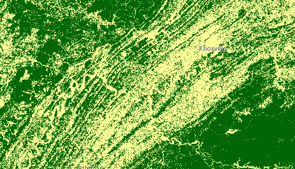
RasterFunction
require(["esri/layers/support/RasterFunction"], function(RasterFunction) { /* code goes here */ });esri/layers/support/RasterFunctionRaster functions specify processing to be done to the image service. They allow the mosaic image service to deliver a dynamically mosaicked image and they can be used to enhance the mosaicked image product by applying processing operations such as image enhancements, and image algebra. See raster functions for a list of functions and their arguments. The following image shows a landcover ImageryLayer rendered with two chained client-side raster functions used to reclass pixel values (Remap) and assign each pixel a new color (Colormap).
Chaining raster functions is accomplished by setting the Raster argument in the functionArguments property to another defined raster function. See example below on chaining a Remap raster function with a Colormap.
var remapRF = new RasterFunction();
remapRF.functionName = "Remap";
remapRF.functionArguments = {
  InputRanges: [-3,10,11,37], // remap pixels with values -3 to 10 to now have value of 1
  OutputValues: [1,2],        // remap pixel values from 11 to 37 to have a value of 2
  Raster: "$$"  // Apply remap to the image service
};
remapRF.outputPixelType = "u8";

var colorRF = new RasterFunction();
colorRF.functionName = "Colormap";
colorRF.functionArguments = {
  Colormap: [
    [1, 255, 0, 0],  // Symbolize pixels with value of 1 using red color
    [2, 0, 255, 0]   // Symbolize pixels with value of 2 using green color
  ],
  Raster : remapRF  // Apply Colormap to output raster from the remap rasterFunction
};

imageLayer.renderingRule = colorRF; // Set rendering rule to final raster function
- See also:
Constructors
- new RasterFunction(properties)
- Parameter:properties Objectoptional
See the properties for a list of all the properties that may be passed into the constructor.
Property Overview
| Name | Type | Summary | Class | |
|---|---|---|---|---|
| String | The name of the class. more details | more details | Accessor | |
| Object | The arguments for the raster function. more details | more details | RasterFunction | |
| String | The raster function name. more details | more details | RasterFunction | |
| String | Defines the pixel type of the output image. more details | more details | RasterFunction | |
| String | The variable name for the raster function. more details | more details | RasterFunction |
Property Details
- Since: ArcGIS API for JavaScript 4.7
The name of the class. The declared class name is formatted as
esri.folder.className.
- functionArguments Object
The arguments for the raster function. The structure depends on the function specified. See raster functions for a list of functions and their arguments. Also parses the arguments of RFT format.
Example:rasterFunction.functionArguments = { "Azimuth":215.0, "Altitude":75.0, "ZFactor":0.3 };
- functionName String
The raster function name. See raster functions for a list of functions and their arguments. The name in the raster function in RFT JSON format is also parsed to functionName.
Example:rasterFunction.functionName = "Stretched"; rasterFunction.name = "GrayScale";
- outputPixelType String
Defines the pixel type of the output image.
Possible Values:"c128"|"c64"|"f32"|"f64"|"s16"|"s32"|"s8"|"u1"|"u16"|"u2"|"u32"|"u4"|"u8"|"unknown"
- Default Value:unknown
Example:rasterFunction.outputPixelType = "u8";
- variableName String
The variable name for the raster function.
Example:rasterFunction.variableName = "DEM";
Method Overview
| Name | Return Type | Summary | Class | |
|---|---|---|---|---|
| * | Creates a new instance of this class and initializes it with values from a JSON object generated from a product in the ArcGIS platform. more details | more details | RasterFunction | |
| Object | Converts an instance of this class to its ArcGIS portal JSON representation. more details | more details | RasterFunction |
Method Details
- fromJSON(json){*}static
Creates a new instance of this class and initializes it with values from a JSON object generated from a product in the ArcGIS platform. The object passed into the input
jsonparameter often comes from a response to a query operation in the REST API or a toJSON() method from another ArcGIS product. See the Using fromJSON() topic in the Guide for details and examples of when and how to use this function.Parameter:json ObjectA JSON representation of the instance in the ArcGIS format. See the ArcGIS REST API documentation for examples of the structure of various input JSON objects.
Returns:Type Description * Returns a new instance of this class.
- toJSON(){Object}
Converts an instance of this class to its ArcGIS portal JSON representation. See the Using fromJSON() guide topic for more information.
Returns:Type Description Object The ArcGIS portal JSON representation of an instance of this class.