CIMSymbol
require(["esri/symbols/CIMSymbol"], function(CIMSymbol) { /* code goes here */ });esri/symbols/CIMSymbolCIMSymbols are used to display multi-layer vector symbols for features and graphics. They allow the user to add more customizations to their symbols, using one or more symbol layers to create the desired effect on the symbol. CIMSymbols can be created from CIMSymbolReference JSON that complies with the CIM specification by passing the JSON to the data property. CIMSymbols can also be created from WebStyleSymbols, using WebStyleSymbol.fetchCIMSymbol().
To get or set the values for color, rotation, and size on the CIMSymbol, use the utility functions found in cimSymbolUtils.
This module is currently in beta. Not all properties in the CIM specification are supported.
Examples:
CIMPointSymbol
The code snippet below shows an example of creating a CIMPointSymbol with one CIMVectorMarker layer which contains a triangle marker graphic as shown below.

const symbol = new CIMSymbol({
  data:  {
    type: "CIMSymbolReference",
    symbol: {
       type: "CIMPointSymbol",
       symbolLayers: [{
           type: "CIMVectorMarker",
           enable: true,
           size: 32,
           frame: {
             xmin: 0,
             ymin: 0,
             xmax: 16,
             ymax: 16
           },
           markerGraphics: [{
             type: "CIMMarkerGraphic",
             geometry: {
               rings: [[[8, 16],[0, 0],[16, 0],[8, 16]]]
             },
             symbol: {
               type: "CIMPolygonSymbol",
               symbolLayers: [{
                 type: "CIMSolidStroke",
                 width: 5,
                 color: [240, 94, 35, 255]
               }]
             }
           }]
       }]
    }
  }
});
Click read more below to see examples for CIMLineSymbol and CIMPolygonSymbol.
Read more
CIMLineSymbol
Since 4.16
The code snippet below shows an example of a CIMLineSymbol with one CIMSolidStroke layer with a dash effect on top of another CIMSolidStroke layer as shown below.

const lineSymbol = new CIMSymbol({
  data: {
    type: "CIMSymbolReference",
    symbol: {
       type: "CIMLineSymbol",
       symbolLayers: [{
         type: "CIMSolidStroke",
         effects: [{
           type: "CIMGeometricEffectDashes",
           dashTemplate: [5, 5],
           lineDashEnding: "FullGap",
           controlPointEnding: "NoConstraint"
         }],
         enable: "true",
         capStyle: "Butt",
         joinStyle: "Round",
         width: 2.6,
         color: [255, 255, 255, 255]
       },
       {
         type: "CIMSolidStroke",
         enable: true,
         capStyle: "Butt",
         joinStyle: "Round",
         width: 3.4,
         color: [0, 0, 0, 255]
       }]
    }
  }
});
CIMPolygonSymbol
Since 4.16
The code snippet below shows an example of a CIMPolygonSymbol with a CIMSolidStroke layer and a CIMSolidFill layer.

const polygonSymbol = new CIMSymbol({
  data: {
     type: "CIMSymbolReference",
     symbol: {
       type: "CIMPolygonSymbol",
       symbolLayers: [{
         type: "CIMSolidStroke", // outlines the polygon
         enable: "true",
         width: 0.4,
         color: [0, 92, 100, 255]
       },
       {
         type: "CIMSolidFill", // fills the polygon
         enable: true,
         color: [151, 219, 100, 150]
       }]
     }
  }
});
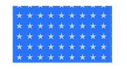
CIMPolygonSymbol with markerPlacement
Since 4.16
The code snippet below shows an example of a CIMPolygonSymbol with CIMVectorMarker symbols placed inside the polygon.
const markerPolygonSymbol = new CIMSymbol({
   data: {
     type: "CIMSymbolReference",
     symbol: {
       type: "CIMPolygonSymbol",
       symbolLayers: [{
         type: "CIMVectorMarker",
         enable: true,
         size: 10,
         markerPlacement: {
           type: "CIMMarkerPlacementInsidePolygon",
           gridType: "Fixed",
           seed: 13,
           stepX: 16,
           stepY: 16,
           clipping: "ClipAtBoundary",
         },
         markerGraphics: [{
           type: "CIMMarkerGraphic",
           geometry: {
             rings: [
               [
                 [0,5],
                 [1.12,1.55],
                 [4.76,1.55],
                 [1.82,-0.59],
                 [2.94,-4.05],
                 [0,-1.91],
                 [-2.94,-4.05],
                 [-1.82,-0.59],
                 [-4.76,1.55],
                 [-1.12,1.55],
                 [0,5]
               ]
             ]
           },
           symbol: {
             type: "CIMPolygonSymbol",
             symbolLayers: [{
               type: "CIMSolidFill",
               enable: true,
               color: [190,210,255,255]
             }]
           }
         }],
         scaleSymbolsProportionally: true,
         respectFrame: true
       },
       {
         type: "CIMSolidFill",
         enable: true,
         color: [0,112,255,255]
       }]
     }
   }
});
Known Limitations
- CIMLineSymbol and CIMPolygonSymbol are not currently supported in a 3D SceneView.
- CIMMeshSymbol is not currently supported.
- CIMTextSymbol is only supported when it is embedded in a CIMPointSymbol or CIMPolygonSymbol. It is not currently supported as a standalone symbol.
- Currently unsupported SymbolLayers: CIMBarChartMarker, CIMCharacterMarker, CIMMaterialSymbolLayer, CIMPieChartMarker, CIMProceduralSymbolLayer, CIMSolidMeshEdge, CIMStackedBarChartMarker, CIMWaterFill, CIMObjectMarker3D, CIMglTFMarker3D, CIMGradientFill, CIMGradientStroke
- The possible values for fontFamilyName property on CIMTextSymbol are dependent upon if you working with a MapView or SceneView. See the Labeling guide page for detailed explanation. Unsupported fonts will fall back to
Arial Unicode MS Regularin MapView andsans-serifin SceneView. - Currently,
minScaleandmaxScaleare not supported on CIMSymbolReference. - Currently,
curvedRingsis not supported. - Currently,
colorproperty expects an array of numbers [r, g, b, a] which is different from the CIM Specification. - Currently, PrimitiveOverride does not work on all the properties, including CIMGeometricEffects.
- Currently, CIMGeometricEffects are not suppported with labels.
- The following markerPlacements are not currently supported on CIMMarker:
CIMMarkerPlacementAlongLineRandomSize,CIMMarkerPlacementAlongLineVariableSize, andCIMMarkerPlacementAtMeasuredUnits. - Symbols with CIMPictureMarkers, CIMPictureStroke, or CIMPictureFill with geometric effects are not currently supported in the Legend widget.
- See also:
Constructors
- new CIMSymbol(properties)
- Parameter:properties Objectoptional
See the properties for a list of all the properties that may be passed into the constructor.
Property Overview
| Name | Type | Summary | Class | |
|---|---|---|---|---|
| CIMSymbolReference | The JSON payload of the CIMSymbolReference. more details | more details | CIMSymbol | |
| String | The name of the class. more details | more details | Accessor | |
| String | The symbol type. more details | more details | CIMSymbol |
Property Details
- data CIMSymbolReference
The JSON payload of the CIMSymbolReference. The CIMSymbolReference is comprised of two main parts - the symbol and the primitive overrides.
Symbol: The
symbolproperty can be of type CIMPointSymbol, CIMLineSymbol, CIMPolygonSymbol, or CIMTextSymbol. Each symbol is made up of one or moresymbolLayers. CIMTextSymbol is an exception - it has native properties, but no symbol layers. Symbol layers are the building blocks of CIM symbols, they combine to make rich graphical depictions. You can configure the shape, color, texture, size, position, etc of each symbol layer, and combine multiple symbol layers to create your desired symbol. The CIM Symbol Builder provides a simple user interface to experiment with symbol layers and their properties.Primitive overrides: Primitive overrides allow you to use Arcade expressions to dynamically change many symbol layer properties from data values. Primitive overrides are defined on the
primitiveOverridesproperty - this property takes in an array of objects, each object representing a primitive override on a specific symbol layer.Example:cimSymbol.data = { type: "CIMSymbolReference", symbol: { type: "CIMLineSymbol", symbolLayers: [{ ... }] }, primitiveOverrides: [{ type: "CIMPrimitiveOverride", primitiveName: "symbol-layer-1", // the name of the symbol layer we want to override propertyName: "Size", // the name of the property on the symbol layer we want to override valueExpressionInfo: { type: "CIMExpressionInfo", title: "Size override", expression: "..." // the expression to change the size of the symbol } }] }
The name of the class. The declared class name is formatted as
esri.folder.className.
Method Overview
| Name | Return Type | Summary | Class | |
|---|---|---|---|---|
| CIMSymbol | Creates a deep clone of the symbol. more details | more details | CIMSymbol | |
| * | Creates a new instance of this class and initializes it with values from a JSON object generated from a product in the ArcGIS platform. more details | more details | Symbol | |
| Object | Converts an instance of this class to its ArcGIS portal JSON representation. more details | more details | Symbol |
Method Details
- clone(){CIMSymbol}
Creates a deep clone of the symbol.
Returns:Type Description CIMSymbol A deep clone of the object that invoked this method. Example:// Creates a deep clone of the graphic's symbol var symLyr = graphic.symbol.clone();
- fromJSON(json){*}static
Creates a new instance of this class and initializes it with values from a JSON object generated from a product in the ArcGIS platform. The object passed into the input
jsonparameter often comes from a response to a query operation in the REST API or a toJSON() method from another ArcGIS product. See the Using fromJSON() topic in the Guide for details and examples of when and how to use this function.Parameter:json ObjectA JSON representation of the instance in the ArcGIS format. See the ArcGIS REST API documentation for examples of the structure of various input JSON objects.
Returns:Type Description * Returns a new instance of this class.
Converts an instance of this class to its ArcGIS portal JSON representation. See the Using fromJSON() guide topic for more information.
Returns:Type Description Object The ArcGIS portal JSON representation of an instance of this class.