SceneModification
require(["esri/layers/support/SceneModification"], function(SceneModification) { /* code goes here */ });esri/layers/support/SceneModificationThe SceneModification is used to perform a client-side geometric modifications. Clip, mask and replace are supported modification types. A collection of scene modifications could be applied with SceneModifications to the modifications for IntegratedMeshLayer property.
Constructors
- new SceneModification(properties)
- Parameter:properties Objectoptional
See the properties for a list of all the properties that may be passed into the constructor.
Property Overview
| Name | Type | Summary | Class | |
|---|---|---|---|---|
| String | The name of the class. more details | more details | Accessor | |
| Polygon | The geometry representing the location of the modification. more details | more details | SceneModification | |
| String | The type of modification to perform. more details | more details | SceneModification |
Property Details
The name of the class. The declared class name is formatted as
esri.folder.className.
- geometry Polygon
The geometry representing the location of the modification. Only polygon geometries are currently supported.
- type String
The type of modification to perform.
Illustration Modification Description 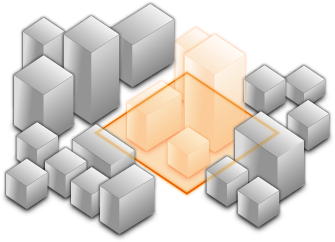
clip - removes selected area Clip-out portions of the integrated mesh to see features below. For example, utility work on gas or water lines in an area. Planners can create a scene in which the integrated mesh is clipped out at a site to expose the water or gas lines below it. 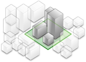
mask - displays only selected area Define an area of interest. Use a polygon and draw only parts of the integrated mesh inside that polygon. For example, if you want to show only a portion of an integrated mesh within the boundaries of a city. 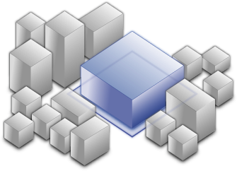
replace - flattens selected area Replace an area of an integrated mesh based on a 3D polygon. For example, to add constructed buildings, flatten the integrated mesh at the footprint of a building so the new building can be visualized. Create different scenarios of the new construction area and share the scenarios as a web scene to discuss with stakeholders. The integrated mesh flattens to the minimum z-vertex of the modification polygon. Possible Values:"clip"|"mask"|"replace"
- Default Value:clip
- See also:
Method Overview
| Name | Return Type | Summary | Class | |
|---|---|---|---|---|
| SceneModification | Creates a clone of this object. more details | more details | SceneModification | |
| * | Creates a new instance of this class and initializes it with values from a JSON object generated from a product in the ArcGIS platform. more details | more details | SceneModification | |
| Object | Converts an instance of this class to its ArcGIS portal JSON representation. more details | more details | SceneModification |
Method Details
- clone(){SceneModification}
Creates a clone of this object.
Returns:Type Description SceneModification A clone of the SceneModification instance that invoked this method.
- fromJSON(json){*}static
Creates a new instance of this class and initializes it with values from a JSON object generated from a product in the ArcGIS platform. The object passed into the input
jsonparameter often comes from a response to a query operation in the REST API or a toJSON() method from another ArcGIS product. See the Using fromJSON() topic in the Guide for details and examples of when and how to use this function.Parameter:json ObjectA JSON representation of the instance in the ArcGIS format. See the ArcGIS REST API documentation for examples of the structure of various input JSON objects.
Returns:Type Description * Returns a new instance of this class.
- toJSON(){Object}
Converts an instance of this class to its ArcGIS portal JSON representation. See the Using fromJSON() guide topic for more information.
Returns:Type Description Object The ArcGIS portal JSON representation of an instance of this class.